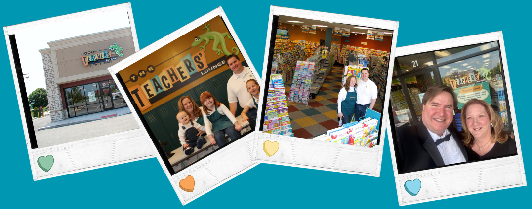
|
Products Per Page
|
Showing 1 through 23 of 23 products. |
Sort by
|
| 1 |

Zoom |
$19.99
Click here for details Add to Cart
|
| 2 |

Zoom |
$19.99
Click here for details Add to Cart
|
| 3 |

Zoom |
$19.99
Click here for details Add to Cart
|
| 4 |

Zoom |
$19.99
Click here for details Add to Cart
|
| 5 |

Zoom |
$24.99
Click here for details Add to Cart
|
| 6 |

Zoom |
$19.99
Click here for details Add to Cart
|
| 7 |

Zoom |
$19.99
Click here for details Add to Cart
|
| 8 |

Zoom |
$19.99
Click here for details Add to Cart
|
| 9 |

Zoom |
$19.99
Click here for details Add to Cart
|
| 10 |

Zoom |
$19.99
Click here for details Add to Cart
|
| 11 |

Zoom |
$99.95
See the world in super-size, with each detail and cartographic touch expanded to fit a full wall! Each mural map comes in three easy-to-hang pieces that affix like wallpaper to your wall. 110" x 76".
Click here for details Add to Cart
|
| 12 |

Zoom |
$99.95
See the world in super-size, with each detail and cartographic touch expanded to fit a full wall! Each mural map comes in three easy-to-hang pieces that affix like wallpaper to your wall. 110" x 76".
Click here for details Add to Cart
|
| 13 |

Zoom |
$199.99
National Geographic’s unique map designs are easy-to-read, yet rich with detail, making them a perfect tool for a wide range of students. Each economical Education Map Pack comes with either 18 of our most popular wall maps, individually tubed, and a coordinating display for keeping your map collection organized.Set Includes: • World Political• World Physical• The Earth’s Fractured Surface• USA Political• USA Physical• Africa• Asia• Australia• Antarctica• Europe • North America• South America• Afghanistan/Pakistan• Canada• Mexico• Middle East• Battles of the Civil War• Indian Country
Click here for details Add to Cart
|
| 14 |

Zoom |
$149.99
National Geographic’s unique map designs are easy-to-read, yet rich with detail, making them a perfect tool for a wide range of students. Each economical Education Map Pack comes with either 11 of our most popular wall maps, individually tubed, and a coordinating display for keeping your map collection organized.Set includes: • World Political• World Physical• The Earth’s Fractured Surface• USA Political• USA Physical• Africa• Asia • Australia• Antarctica• Europe• North America• South America
Click here for details Add to Cart
|
| 15 |

Zoom |
$24.95
Unlike other classroom poster maps, National Geographic maps utilize the Winkel-Triple projection, which provides the best combination of size, shape, and distance, giving students the best possible visual representation of the Earth on a flat surface. Laminated. 51" x 40". This grade appropriate content map series showcases numerous insets to help teach early level fundamentals such as scale, directions, and the continents.
Click here for details Add to Cart
|
| 16 |

Zoom |
$24.95
Unlike other classroom poster maps, National Geographic maps utilize the Winkel-Triple projection, which provides the best combination of size, shape, and distance, giving students the best possible visual representation of the Earth on a flat surface. Laminated. 51" x 40". This grade appropriate content map series showcases numerous insets to help teach early level fundamentals such as scale, directions, and the continents.
Click here for details Add to Cart
|
| 17 |

Zoom |
$29.99
Unlike other classroom poster maps, National Geographic maps utilize the Winkel-Triple projection, which provides the best combination of size, shape, and distance, giving students the best possible visual representation of the Earth on a flat surface. Laminated. 51" x 40". This grade appropriate content map series showcases numerous insets to help teach early level fundamentals such as scale, directions, and the continents.
Click here for details Add to Cart
|
| 18 |

Zoom |
$24.95
Unlike other classroom poster maps, National Geographic maps utilize the Winkel-Triple projection, which provides the best combination of size, shape, and distance, giving students the best possible visual representation of the Earth on a flat surface. Laminated. 51" x 40". An index at the bottom of the World map helps students find every country and capital on Earth. The USA map includes the Interstate System and an inset of Alaska as it compares to the lower 48 states in overall size.
Click here for details Add to Cart
|
| 19 |

Zoom |
$24.95
Unlike other classroom poster maps, National Geographic maps utilize the Winkel-Triple projection, which provides the best combination of size, shape, and distance, giving students the best possible visual representation of the Earth on a flat surface. Laminated. 51" x 40". An index at the bottom of the World map helps students find every country and capital on Earth. The USA map includes the Interstate System and an inset of Alaska as it compares to the lower 48 states in overall size.
Click here for details Add to Cart
|
| 20 |

Zoom |
$29.99
Unlike other classroom poster maps, National Geographic maps utilize the Winkel-Triple projection, which provides the best combination of size, shape, and distance, giving students the best possible visual representation of the Earth on a flat surface. Laminated. 51" x 40". An index at the bottom of the World map helps students find every country and capital on Earth. The USA map includes the Interstate System and an inset of Alaska as it compares to the lower 48 states in overall size.
Click here for details Add to Cart
|
| 21 |

Zoom |
$24.95
Unlike other classroom poster maps, National Geographic maps utilize the Winkel-Triple projection, which provides the best combination of size, shape, and distance, giving students the best possible visual representation of the Earth on a flat surface. Laminated. 51" x 40".
Click here for details Add to Cart
|
| 22 |

Zoom |
$24.95
Unlike other classroom poster maps, National Geographic maps utilize the Winkel-Triple projection, which provides the best combination of size, shape, and distance, giving students the best possible visual representation of the Earth on a flat surface. Laminated. 51" x 40".
Click here for details Add to Cart
|
| 23 |

Zoom |
$29.99
Unlike other classroom poster maps, National Geographic maps utilize the Winkel-Triple projection, which provides the best combination of size, shape, and distance, giving students the best possible visual representation of the Earth on a flat surface. Laminated. 51" x 40".
Click here for details Add to Cart
|